![](/images/other/stat-length.png)
![Trail On foot Am Mellensee - Saalower Mühlenweg - Photo](https://media.geolcdn.com/t/1900/400/ext.pjpeg?maxdim=2&url=https%3A%2F%2Fmedia.geolcdn.com%2Ff%2F8776985a-8699-4d13-87c9-b0841b4bde1e.jpeg)
Saalower Mühlenweg
SityTrail - itinéraires balisés pédestres
Tous les sentiers balisés d’Europe PRO
![Length](/images/other/stat-length.png)
Length
7.8 km
![Max alt](https://static1.geolcdn.com/siteimages/upload/files/1508320355ic_sort_altitude_max_24dp.png)
Max alt
53 m
![Uphill gradient](https://static1.geolcdn.com/siteimages/upload/files/1508320355ic_sort_den_pos_24dp.png)
Uphill gradient
58 m
![Km-Effort](/images/other/stat-length.png)
Km-Effort
8.5 km
![Min alt](https://static1.geolcdn.com/siteimages/upload/files/1508320355ic_sort_altitude_min_24dp.png)
Min alt
36 m
![Downhill gradient](https://static1.geolcdn.com/siteimages/upload/files/1508320355ic_sort_den_neg_24dp.png)
Downhill gradient
58 m
![Boucle](https://static1.geolcdn.com/siteimages/upload/files/16400158638029165_repeat_loop_refresh_sync_direction_icon.png)
Boucle
Yes
Signpost
Creation date :
2022-02-11 13:16:50.371
Updated on :
2022-02-11 13:16:50.371
![On foot](https://static1.geolcdn.com/sitytour/trail-icons/100.png)
1h56
Difficulty : Easy
![Scan this QR Code to open this trail in the SityTrail application](https://capi.geolives.com/qq0zvz2zws4bq2lad0pu/sitytour/trails/3089812/qr.png?size=200)
FREE GPS app for hiking
About
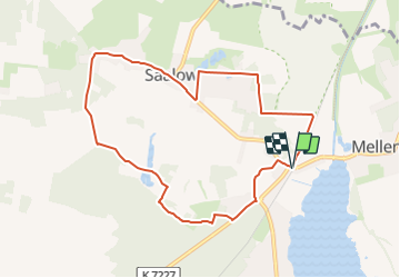
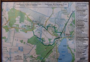
Trail On foot of 7.8 km to be discovered at Brandenburg, Teltow-Fläming, Am Mellensee. This trail is proposed by SityTrail - itinéraires balisés pédestres.
Description
proMellensee e.V. - Verein für Umwelt, Natur und sanften Tourismus rund um Mellensee
Website: https://www.promellensee.de/saalower-mühlenweg.html
Positioning
Country:
Germany
Region :
Brandenburg
Department/Province :
Teltow-Fläming
Municipality :
Am Mellensee
Location:
Mellensee
Start:(Dec)
Start:(UTM)
390871 ; 5782718 (33U) N.
Comments
Trails nearby
![Trail On foot Am Mellensee - Kloserrundwanderweg - Photo](https://media.geolcdn.com/t/375/260/ext.jpg?maxdim=2&url=https%3A%2F%2Fmedia.geolcdn.com%2Ff%2Fd17d0c2d-4320-4dfb-b0bf-f7eb7e15ac6c.jpeg)
![On foot On foot](https://static1.geolcdn.com/sitytour/trail-icons/100.png)
Kloserrundwanderweg
On foot
Easy
Am Mellensee,
Brandenburg,
Teltow-Fläming,
Germany
![](/images/other/stat-length.png)
5.5 km | 6 km-effort
1h 21min
![](https://static1.geolcdn.com/siteimages/upload/files/16400158638029165_repeat_loop_refresh_sync_direction_icon.png)
Yes
![Trail On foot Am Mellensee - Moke-Notte Rundweg - Photo](https://media.geolcdn.com/t/375/260/ext.jpg?maxdim=2&url=https%3A%2F%2Fmedia.geolcdn.com%2Ff%2F38f5caa4-1935-4a90-aeaf-0fe18d310206.jpeg)
![On foot On foot](https://static1.geolcdn.com/sitytour/trail-icons/100.png)
Moke-Notte Rundweg
On foot
Easy
Am Mellensee,
Brandenburg,
Teltow-Fläming,
Germany
![](/images/other/stat-length.png)
5.2 km | 5.5 km-effort
1h 14min
![](https://static1.geolcdn.com/siteimages/upload/files/16400158638029165_repeat_loop_refresh_sync_direction_icon.png)
Yes
![Trail On foot Am Mellensee - Mellenseer Heideweg - Photo](https://media.geolcdn.com/t/375/260/ext.jpg?maxdim=2&url=https%3A%2F%2Fmedia.geolcdn.com%2Ff%2F49b9d9c7-5121-4b1c-b6a4-692a961fc759.jpeg)
![On foot On foot](https://static1.geolcdn.com/sitytour/trail-icons/100.png)
Mellenseer Heideweg
On foot
Easy
Am Mellensee,
Brandenburg,
Teltow-Fläming,
Germany
![](/images/other/stat-length.png)
8.9 km | 9.9 km-effort
2h 15min
![](https://static1.geolcdn.com/siteimages/upload/files/16400158638029165_repeat_loop_refresh_sync_direction_icon.png)
No
![Trail On foot Am Mellensee - Mellenseer Rundwanderweg - Photo](https://media.geolcdn.com/t/375/260/ext.jpg?maxdim=2&url=https%3A%2F%2Fmedia.geolcdn.com%2Ff%2F64f18cce-f838-44f5-8861-41ba1c709efd.jpeg)
![On foot On foot](https://static1.geolcdn.com/sitytour/trail-icons/100.png)
Mellenseer Rundwanderweg
On foot
Easy
Am Mellensee,
Brandenburg,
Teltow-Fläming,
Germany
![](/images/other/stat-length.png)
13.2 km | 14.7 km-effort
3h 20min
![](https://static1.geolcdn.com/siteimages/upload/files/16400158638029165_repeat_loop_refresh_sync_direction_icon.png)
No
![Trail On foot Am Mellensee - Klausdorfer Rundweg - Photo](https://media.geolcdn.com/t/375/260/ext.jpg?maxdim=2&url=https%3A%2F%2Fmedia.geolcdn.com%2Ff%2Fae54801f-deee-48c3-89e9-ab6752d0644c.jpeg)
![On foot On foot](https://static1.geolcdn.com/sitytour/trail-icons/100.png)
Klausdorfer Rundweg
On foot
Easy
Am Mellensee,
Brandenburg,
Teltow-Fläming,
Germany
![](/images/other/stat-length.png)
3.9 km | 4.5 km-effort
1h 1min
![](https://static1.geolcdn.com/siteimages/upload/files/16400158638029165_repeat_loop_refresh_sync_direction_icon.png)
No
![Trail On foot Am Mellensee - Saalower Höllenbergweg - Photo](https://media.geolcdn.com/t/375/260/ext.jpg?maxdim=2&url=https%3A%2F%2Fmedia.geolcdn.com%2Ff%2F1eddf8e9-65bb-40c6-892f-e103d5390469.jpeg)
![On foot On foot](https://static1.geolcdn.com/sitytour/trail-icons/100.png)
Saalower Höllenbergweg
On foot
Easy
Am Mellensee,
Brandenburg,
Teltow-Fläming,
Germany
![](/images/other/stat-length.png)
7.9 km | 9.3 km-effort
2h 6min
![](https://static1.geolcdn.com/siteimages/upload/files/16400158638029165_repeat_loop_refresh_sync_direction_icon.png)
No
![Trail On foot Zossen - Rundwanderweg Schünow - Horstfelde - Photo](https://media.geolcdn.com/t/375/260/ext.jpg?maxdim=2&url=https%3A%2F%2Fmedia.geolcdn.com%2Ff%2F88e7ddc4-5609-4a3f-8976-ac1fd69e7f11.jpeg)
![On foot On foot](https://static1.geolcdn.com/sitytour/trail-icons/100.png)
Rundwanderweg Schünow - Horstfelde
On foot
Easy
Zossen,
Brandenburg,
Teltow-Fläming,
Germany
![](/images/other/stat-length.png)
11.6 km | 12.9 km-effort
2h 56min
![](https://static1.geolcdn.com/siteimages/upload/files/16400158638029165_repeat_loop_refresh_sync_direction_icon.png)
No